How to find the Tall
Tall Zira'a - GPS coordinates: 32°37'14'' N; 35°39'22'' E
UTM (WGS-84) 749213 E; 3612339N
There are two possible routes to Tall Zira'a from Amman:
1. Take the main highway from Amman through Suweileh and As-Salt to highway no. 27 towards the Jordan Valley. In Muttalath you will meet with highway no. 65 which runs north along the Jordan from the Dead Sea. Follow this road for 53 km to the north until you reach North Shuna. You will pass Tell Der ´Alla (Sukkot) and Tabaqat Fahl (Pella) .
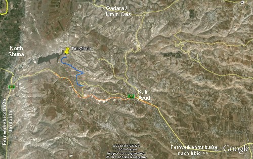
10 km after you have passed the junction with the westbound road from Israel to the left ( Jordan River Crossing), you will find, on your right (east), before you get to Ash-Shuna, the new 4-lane highway no. 10 to Irbid (in red on the map). Take this road as far as junction eth-Thayibe and take the next possible u-turn, about 1 km later. Then drive back to junction eth-Thayibe leave the highway at the next possible exit.
Take this road (thin yellow road on the map) for 1 km and you will come to a hairpin bend. Drive for another 500 m and then take the small road on the left (blue road). Follow this road to the northwest and you will reach Tall Zira'a after 2 km.
2. You can also take the highway from Amman to the north via Jerash to Ar-Ramtha. Pass by Jerash and then after 20 km take the road to Irbid. There you will meet highway no. 10 towards the Jordan Valley ( Northshuna/ Jordan River Crossing, in red on the map). After junction Kufr Asad (traffic light), drive steeply downwards and take the next possible exit to the right.
Take this road (thin yellow road on the map) for 1km and you will come to a hairpin bend. Drive for another 500 m and then take the small road on the left (blue road). Follow this road to the northwest and you will reach
Tall Zira'a after 2 km.
For enlarging - please, click the map!
 Close Window
 print
print